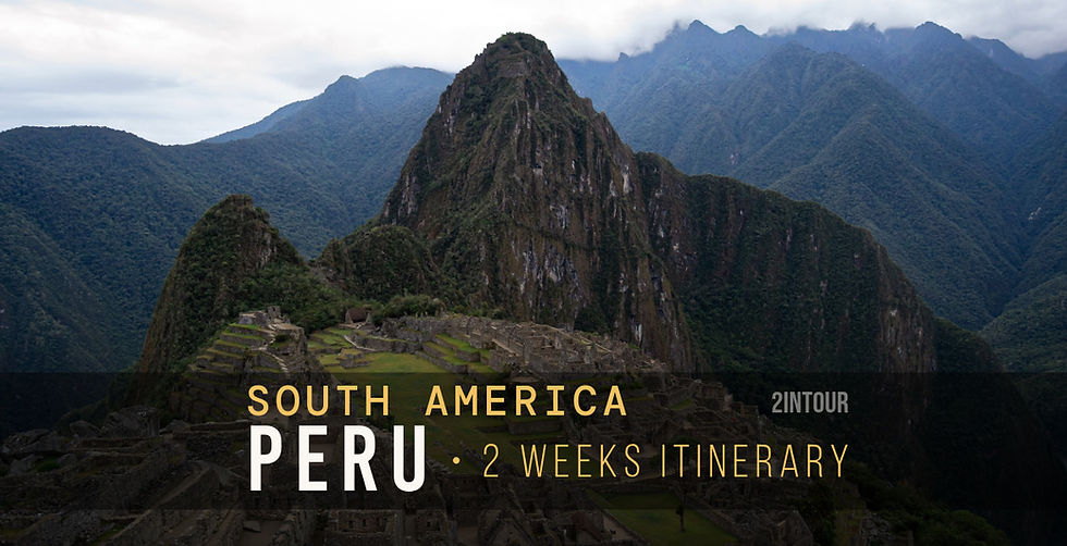
Colca Canyon: all the places you can't miss
- Apr 18, 2020
- 7 min read
Updated: 5 days ago
Looking for tips to plan your next trip to Southern Peru? In this article, we dive into an exciting stop on our journey: the Colca Canyon Valley. A spectacular 300 km road trip that, starting from the city of Arequipa, crosses Andean highlands, high-altitude passes, nature reserves, and traditional villages.

"The best view comes after the hardest climb"
If you’re looking for more information, you might also be interested in our complete two-week itinerary, packed with practical tips based on our firsthand experience and answers to frequently asked questions from other travelers.
Colca Canyon valley
Colca Canyon, located in southern Peru, is one of the deepest canyons in the world – in some areas, the drop reaches nearly 3,400 meters from the Colca River flowing at the valley floor. From a scenic perspective, the canyon’s very structure is spectacular: towering rock walls alternate with ancient agricultural terraces, picturesque villages, and lush pastures where llamas, alpacas, and vicuñas are still raised today. In addition to its extraordinary geography, Colca Canyon is famous for the Andean condor, which can frequently be observed in this area.

Getting around Colca Canyon requires a bit of planning: most roads are paved but narrow, with breathtaking views that invite you to stop frequently. The best way to explore the canyon is by car or small guided tours, offering more flexibility to make stops, take photos, and enjoy the scenery at a relaxed pace.
Below, we’ve gathered the main highlights of our self-guided itinerary.
From Arequipa to the Mirador de los Volcanos
Our new road-trip adventure begins in Arequipa – don’t miss our dedicated article about exploring the city – where, after visiting the Yanahuara viewpoint and enjoying a quick lunch, we hit the road towards Colca Canyon, aiming to make the most of the daylight and enjoy the stops along the way.
Just a few minutes into the drive, we find ourselves on a stunning scenic road that, in less than 200 km, takes us to the Reserva Nacional Salinas y Aguada Blanca. This breathtaking landscape, originally established as a conservation center for local wildlife, is now the main water reserve of the region, thanks to its crystal-clear lakes and vast, untouched pastures. Along the way, it’s easy to spot vicuñas, llamas, and alpacas grazing freely, offering perfect opportunities for nature photography enthusiasts like us. We stop briefly at a small roadside rest area for a Mate de Coca, ideal for acclimating to the altitude, and pick up some charming souvenirs from a local woman who sells handmade hats, perfect for protecting against the cold and wind at high altitudes. The road invites frequent stops – every viewpoint is an opportunity to capture photos and admire the wild beauty of the Andean landscape.
The next stretch climbs more steeply up to Paso de Patapampa, one of the highest passes in Peru, at 4,910 meters above sea level. Here lies the famous Mirador de los Volcanes, offering incredible views of eight imposing volcanoes. With a bit of luck, you might even witness an unexpected eruption of Sabancaya volcano, a breathtaking experience that makes the stop even more unforgettable.
After the pass, the road gradually descends to Chivay, at 3,630 meters. Before reaching our hotel for the night – the charming Pozo del Cielo – it’s worth stopping at the La Calera hot springs. Here, a sequence of five natural pools with water up to 40°C allows you to relax and enjoy the last rays of sun on the mountains, the perfect way to recharge after a full day of winding roads, high-altitude landscapes, and unforgettable scenery.
Yanque and Mirador Cruz del Condor
The next day, we wake up early as usual, despite a nearly sleepless night – likely a result of the significant altitude change from the previous day – and after a hearty breakfast, we head to the first stop of the day: Yanque. Yanque is a small village where time seems to have stood still. Here, we watch a charming traditional dance taking place right in the main square. With our cameras always at the ready, we take the opportunity to photograph the locals dressed in their traditional attire, a genuine dive into the local culture that turns every shot into a little treasure.
The morning is clear and sunny, and our excitement grows as we approach the Mirador Cruz del Condor, one of the best vantage points to admire the majestic Andean condors. By starting early, around 8 a.m., the small road is still free from the tourist buses that usually crowd the area, allowing us to stop whenever the landscape calls for a photograph.
With a bit of luck, we can already spot a few condors in the distance even before reaching the Mirador. The real spectacle begins once we park the car nearby. A large family of condors seems to be waiting for our arrival, perched on a massive rock right beside the road. From that height, one by one, they take flight with just a few wingbeats, catching the canyon’s warm thermals that help them soar majestically into the sky. It’s a breathtaking experience: watching these winged giants glide so freely is one of the most memorable moments of the entire trip. We spend a couple of hours here, letting ourselves be enchanted by the panorama and savoring the silence and grandeur of the canyon.

Maca
When hundreds of tourists begin to arrive and the area starts to fill up, we know it’s time to move on and continue our adventure. The next stop is Maca, another small village that offers perfect opportunities for authentic photography. Here, we can watch and capture locals with their domesticated baby alpacas, adorable and curious, and take a stroll around the main square, where a charming church stands as the heart of local life.
After a quick lunch, it’s time to pack our bags and head to the next destination: Puno and Lake Titicaca, one of South America’s most iconic lakes. The road promises new landscapes, fresh experiences, and undoubtedly, many more stories to tell.
Andean Condor
The Andean condor (Vultur gryphus) is one of the largest flying birds in the world. It can weigh up to 15 kg and have a wingspan of 3.3 meters, allowing it to take flight with ease in the skies of the Andes. Despite its massive size, the condor is an expert glider, able to use rising thermal currents to cover long distances with very few wingbeats, greatly reducing fatigue.
In Andean tradition, the condor is much more than just a bird: it is a symbol of strength, freedom, and the connection between heaven and earth. In local beliefs, it plays an important role as a protector of communities.
In pre-Inca monuments and art, the condor is often depicted in a stylized form on ceramics, textiles, and sculptures, usually alongside two other animals: the puma and the serpent. Together, these three creatures represent the sacred triad, symbolizing the sky, the earth, and the underworld (or afterlife).
PRACTICAL INFO
Altitude
The road from Arequipa climbs to a maximum of 4,910 meters above sea level, offering breathtaking views of the many volcanoes in the area. It’s essential to acclimate gradually: avoid unnecessary physical effort as soon as you step out of the car and take the time needed to adjust to the altitude
Plan at least 2 days
To truly enjoy the Colca region, it’s recommended to plan at least two days and one night. The best chances to spot the condors are early in the morning, when the skies are clear and thermal currents help the birds soar. Don’t miss a relaxing soak in the hot springs at sunset, a rejuvenating experience after a day of canyon views and high-altitude roads.
Food and hydration
At this altitude, digestion is much slower than usual. It’s better to have a light dinner, such as a warm soup, and avoid alcoholic drinks. Staying well-hydrated is essential to handle the altitude comfortably.
Tips for amateur photographers
ou don’t need a massive telephoto lens to capture stunning shots of condors. Along the road, there are many strategic viewpoints where the birds fly right overhead, perfect for close-up photos. We used an AF-S DX NIKKOR 55-200mm f/4-5.6G ED VR II, affordable but delivering excellent results. Even with simple equipment, the combination of light, landscape, and the majesty of the condors makes for unforgettable images.
FREQUENTLY ASKED QUESTIONS
Where is Colca Canyon and how do I get there from Arequipa?
Colca Canyon is located in southern Peru, about 200 km from Arequipa. It can be reached by private car or organized tours. The duration of the journey depends largely on the number of stops you make along the way. We recommend allowing plenty of time to fully enjoy the stunning landscapes and let your body acclimate to the altitude. In any case, expect at least 4 and a half hours of driving
When is the best time to visit Colca Canyon?
Generally, the dry season, from April to September, offers clear skies, pleasant temperatures, and better chances to spot condors. Our trip took place between late August and September, and we found the conditions ideal.
Where can I see Andean condors and what is the best viewpoint?
With a bit of luck, condors can be spotted along the road that runs beside the canyon. They use rising air currents and often soar from the rocks near the roadside. The most famous viewpoint is the Mirador Cruz del Condor, near Chivay. Condors are most active early in the morning.
Do I need a guide to visit Colca Canyon?
A guide is not mandatory; in our experience, a driver who knows the area is usually enough to enjoy the scenery and spot condors. However, a local guide can enhance the experience with insights about culture, flora, and fauna, and also provide extra safety.
What can I see along the route to Colca Canyon?
In addition to the many viewpoints offering breathtaking views of volcanoes and ancient agricultural terraces, we visited villages such as Yanque, Chivay, and Maca, which add cultural charm to the journey.
To discover more about these place, have a look to our posts and stories dedicated to Peru dated August/September 2019 on our Instagram page @2intour

Comments